
There are exciting times ahead, and that’s something we really need in the world these days.
Much as Earth-orbiting space stations have advanced since 1972, humans have been stuck in low Earth orbit for far too long.
This definitely wasn’t what a lot of us expected when the Apollo Astronauts set foot upon the Moon all those years ago.
When Neil and Buzz stepped onto the surface, I, as a 7-year-old boy, was totally inspired, and it set me on a path with my passion for astronomy and spaceflight.
Artemis has once again triggered that excitement within me. 😀
They are not going to land on the Moon this time; that’s for at least Artemis IV.
But they will be flying out beyond and around the back of the Moon, the furthest living humans have travelled from Earth.
NOTE it’s NOT THE DARK SIDE. That’s a Pink Floyd Album.

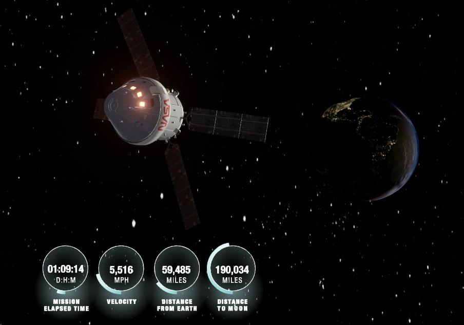
What a trip they will have, watching the Earth shrink as the mission progresses during the first half.
I can’t wait to see their pictures.
If circumstances are right, we MIGHT just be able to image Artemis during the mission as it makes its way out to the Moon and back again.
Timeline.
Day 1. April 1st. Launch Date. In Earth orbit, so it will appear as a satellite.
Days 2 – 4. Outbound transit.
Days 5 – 6. Lunar Fly-by.
Day 6. Closest to the Moon (41,000 miles) and furthest from Earth (250,000 miles).
(The farthest humans have ever travelled from Earth previously was 248,655 miles, which was achieved by the Apollo 13 crew, Jim Lovell, Jack Swigert, and Fred Haise, on April 14, 1970 after the accident which crippled their service module.
Days 7 – 10. Return journey and splashdown in the Pacific Ocean.
The circumstances of spotting it are very tricky from the UK, as the Moon will be low down in Scorpius throughout the mission.
Now that Artemis II is in its Lunar insertion orbit, it’s more predictable, so I have used Horizons (Link at Bottom) to calculate the position as seen from Cambridge for the next two days.
>..... Elevation Cut-off Requested .....<

 2026-Apr-04 00:00  m  16 03 15.64 -27 03 47.9     n.a.    n.a.  0.00137702217998   1.2356980  129.8497 /L   Sco   11.099198   136.08891   81.496772        3.307     n.a.
 2026-Apr-04 01:00  m  16 03 42.75 -27 10 55.1     n.a.    n.a.  0.00140694698953   1.2536529  129.7606 /L   Sco   7.6898872   143.77241   84.044446        3.293     n.a.
 2026-Apr-04 02:00  m  16 03 58.16 -27 16 08.8     n.a.    n.a.  0.00143744095022   1.2823776  129.7220 /L   Sco   4.9171781   149.47075   86.188295        3.234     n.a.
 2026-Apr-04 03:00  m  16 04 06.95 -27 19 22.4     n.a.    n.a.  0.00146871548087   1.3178100  129.7164 /L   Sco   2.7380728   144.30688   87.887464        3.165     n.a.
 2026-Apr-04 04:00 Am  16 04 14.22 -27 20 37.4     n.a.    n.a.  0.00150087867313   1.3554780  129.7255 /L   Sco   1.8315153   99.482451   88.595739        3.071     n.a.
 2026-Apr-04 05:00 Cm  16 04 24.72 -27 20 03.0     n.a.    n.a.  0.00153392945797   1.3908386  129.7317 /L   Sco   3.3256886   64.971079   87.461387         n.a.     n.a.

>..... Daylight Cut-off Requested .....<


>..... Elevation Cut-off Requested .....<

 2026-Apr-05 01:00  m  16 25 56.38 -27 42 11.5     n.a.    n.a.  0.00205282422312   0.7487645  125.8384 /L   Sco   4.1962297   187.09291   82.082985        3.159     n.a.
 2026-Apr-05 02:00  m  16 25 50.34 -27 45 44.3     n.a.    n.a.  0.00207133360357   0.7911916  125.8872 /L   Sco   3.5479471   215.08207   83.593752        3.135     n.a.
 2026-Apr-05 03:00  m  16 25 39.09 -27 47 57.6     n.a.    n.a.  0.00209095676851   0.8406396  125.9598 /L   Sco   3.1981572   241.39562   84.507430        3.088     n.a.
 2026-Apr-05 04:00 Am  16 25 26.13 -27 48 47.8     n.a.    n.a.  0.00211181054697   0.8927195  126.0438 /L   Sco   2.7990373   267.00771   85.423879        3.022     n.a.
 2026-Apr-05 05:00 Cm  16 25 14.95 -27 48 17.0     n.a.    n.a.  0.00213390336312   0.9428672  126.1267 /L   Sco   2.3353523   299.58622   86.344390         n.a.     n.a.

>..... Daylight Cut-off Requested .....<
As expected, it is low down for us, but worse than first calculated, in Scorpius, so it will be extremely hard to catch it so low down in our skies.
I’ve now created a map using these new coordinates, showing its possible path on the 4th and 5th below:
I selected these times because that’s when Artemis is above our horizon, and it’s nighttime.
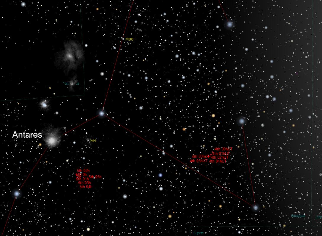
Click on the image for a closer view.
I have also created a Stellarium script to plot the positions for the next few days for you.
I’ll update this if things change, as some trajectory corrections are coming up.
Download it by right-clicking the link below and choosing, Save Link As…
www.star-gazing.co.uk/Downloads/Artemis-II-Stellarium-Plot.ssc
Double-click on the saved file and Stellarium should open if you have it installed.
Potential magnitude estimates during the mission from The Night Sky Guy are shown in the image below, who suggests even smartscopes may be able to image it during part of the mission:

I can still capture the Webb Space Telescope, which is about 17th magnitude, so I should be able to capture this one throughout the mission. However, being quite low down, Artemis is likely to appear a bit fainter than the estimates shown above.
Whether we will be able to image it will depend on the spacecraft’s orbit and whether it will be above our horizon.
We will only know the actual path it will take until three and a half hours after launch, once it is on its way.
It will only appear as a faint star-like point, but I’m certainly going to give it a try, that’s if it does launch. 🤞
It would be an absolute thrill for me to capture this.
Space Weather has put together a guide on how to do this using NASA’s Horizon tracking page, which can be viewed here:
https://spaceweather.com/images2026/28mar26/horizons.html
They’ve also got a nice Trajectory Visualisation:
https://www.heavens-above.com/artemis
NASA’s Horizon Page is here:
https://ssd.jpl.nasa.gov/horizons/app.html
It could also be worthwhile to check Project Pluto’s website to see if they have info once Artemis II launches:
https://projectpluto.com/sat_eph.htm?
This has proved very accurate for tracking the Webb Space Telescope.
For live progress on Artemis II check out the Live Launch Timetable:
https://x37b.nl/artemis
Artemis II – Live:
https://www.nasa.gov/missions/artemis-ii/arow
If it will be visible from your location and you give it a go, Good luck folks.
Fantastic compilation of information and links.
Thanks so much for putting this out there.
Look to the skies!
Thanks David.
Just keeping my fingers crossed that it does launch as planned.
Well done Dave it’s a great resource. Hope it’s simple enough to use the NASA horizons tool and to be able to follow the sub orbital pass
Tremendous information Dave. I’ll see if I can catch a glimpse if we have clear skies at the right times
Good luck.
Great website! The Artemis script is extremely useful. So, it seems its predicted trajectory for the mornings of April 9 and 10 are now much higher in the sky than a few days ago. Is that correct? It looks like it will be visible at 20 to 30 degrees above the horizon now. Is that correct?
PS: sorry, I should have also included that im at 39 N, in Spain 🙂